
Back to the main Sukkertoppen page and detailed information for this route.
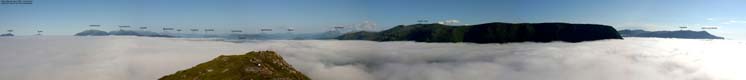
On-call duty week, and I'm city bound. That doesn't matter when the sea fog is rolling in, causing spectacular views. I hadn't seen city fog like this since back in Bergen, Dec 2001, when the airport was closed for days.
I wanted to traverse the mountain, and went off-trail from the northeast side. I planned to descend "Trollråsa" (the west ridge), and it would be convenient to have the car on the right side of the mountain.
I carried the dog up the cumbersome, yet quite open forest, until we reached the normal route by the mast. We reached the top approx. 18:30PM and could enjoy the sea of fog that came in from the ocean, reaching to Spjelkavik. I then descended the west ridge with my dog in the backpack and followed the gravel road back to the car, which I found on the third side-road attempt.
To Sukkertoppen


Sukkertoppen views


Descent


No Javascript:
1 2 3 4 5 6 7 8 9 10 11 12 13 14 15 16 17 18
 westcoastpeaks.com
Other Møre & Romsdal mountains
Other Norwegian mountains
westcoastpeaks.com
Other Møre & Romsdal mountains
Other Norwegian mountains