
Norwegian Mountains, Sogn og Fjordane
Stadlandet
Svartehornet, 475m
| Fylke/Kommune: | Sogn og Fjordane county/Selje municipality | ||||||||||
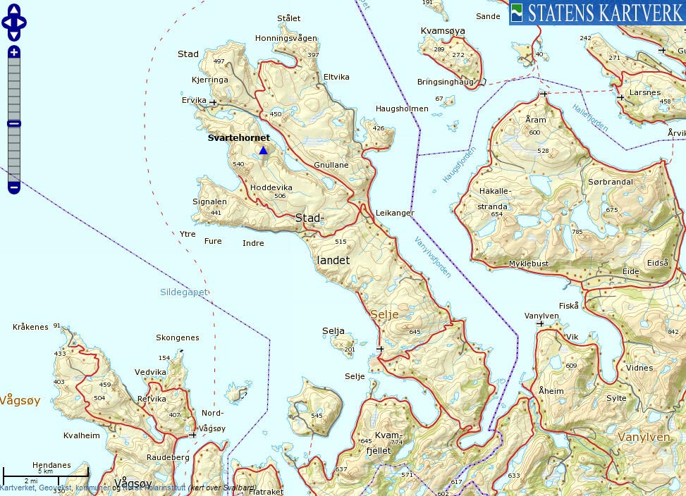
| Maps: | 1019-II Stad (Statens Kartverk, Norge 1:50 000) | ||||||||||
| Primary factor: | 110m | ||||||||||
| Hiked: | Mar 2012 | ||||||||||
| See also: |
| ||||||||||
| See also : | Other Sogn og Fjordane mountains on westcoastpeaks.com |

Svartehornet
(Click for larger image)
Introduction
Svartehornet is a located on the south side of Dalsbøvatnet on Stadlandet, and (apparently) there is no established trail up the mountain. The shortest off-trail route (described on this page) runs from Dalsbøen, and the ascent is quite cumbersome due to bog and turfs, in addition to a steep finish.
East of Svartehornet, you'll find the Sætrefjellet - Nobba plateau and a mountain face that's quite unlike anything else in western Norway;

A grand wall above Sætrevatnet
(Click for larger image)
Primary factor:
Svartehornet (Norge 1:50,000: 475m, Økonomisk Kartverk: 475,25m, UTM 32 V 300879 6896285) has a primary factor of 110m towards the higher parent mountain Mosekleivhornet (540m). The defining saddle (approx. 32 V 300495 6895987) is found west of Eidslivatnet. Ref. Økonomisk Kartverk (5m contours), the saddle is within the range 360-365m, interpolated to 363m. However - as lake Eidslivatnet is 364,2m, the saddle has to be higher. Subsequently, the saddle height has been set to 365m.

Svartehornet ahead
(Click for larger image)
Google map
Google's interactive map. You can zoom, pan and click on the markers.
|
|
|

Trail descriptions
| This disclaimer is regarding all of the literature and instructional guides posted on the westcoastpeaks.com website. These instructions are guidelines only, and should not be used in lieu of common sense or judgment when attempting any of the actions involved or instructed. Westcoastpeaks nor myself will not be liable nor will it indemnify any form of compensation to anyone who has injured, harmed or even killed themselves or others while following any of the instructions written within the website. It should be noted by any persons willing to undertake any of the instructions provided that mountains offer varying levels of risk, regardless of size or incline. Risks to be considered are as follows but not limited to: wild animals, weather, the terrain, bad judgment, inappropriate or insufficient equipment, improper training or experience and of course, bad luck... |
|
Route 1: Dalsbøen - Svartehornet (summer/autumn)
|
|


This route description is valid per Mar 2012
Access
(all distances are approx. distances)
The starting point for this route description is the place Åheim by Vanylvsfjorden.
At the Stadlandet/Måløy junction (signposted) south of the river, follow RV620 towards Stadlandet. Drive this road 7,4km to the Selje/Stadlandet junction (N62.01130 E5.46046, signposted) above Kjødspollen. Turn right towards Stadlandet/Vestkapp and drive 20,2km to the Hoddevik/Honngingsvåg junction (N62.12108 E5.30288, signposted) above Leikanger. Turn right towards Honningsvåg and drive 6,2km to Dalsbøen between lakes Sætrevatnet and Dalsbøvatnet. Turn left and follow the gravel road for 270 meters (it curves around a barn). Find parking here (N62.14655 E5.21060).
The route:

The route, as seen in Google Earth
(Click for larger image)
Follow the gravel road (turn right at the first fork) to the bridge across the drain from Sætrevatnet. At the gate on the other side of the bridge, turn right, head northwest for 70-80 meters and locate a vague path that runs to the west.
Your general direction throughout is straight west. Stick to the path as long as it make sense. Eventually, this path takes you into Kupa, which is not where you should be going. Cross Kupeelva (should not be a difficult task) and head directly up Svartehornet's east ridge. If this ridge is too steep for your taste, then head into Kupa and find an ascent route that suits you better.
The top of Svartehornet is marked by a stick and a few rocks. Excellent views from the top!

The route to Svartehornet
(Click for larger image)
Pictures and Trip reports:
- Mosekleivhornet - Svartehornet - Nobba - Solumskardura, Mar 17 2024
- Svartehornet, Mar 4 2012
- Svartehornet seen from other mountains
 westcoastpeaks.com
Other Sogn og Fjordane mountains
Other Norwegian mountains
westcoastpeaks.com
Other Sogn og Fjordane mountains
Other Norwegian mountains