
|


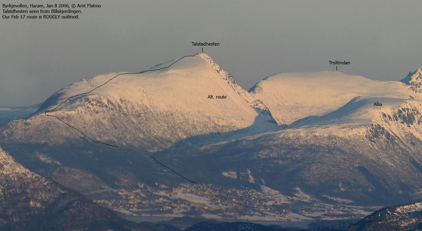
Talstadhesten (The Talstad Horse) is the 5th highest mountain in Fræna kommune, but has the highest primary factor (805m). The mountain has roads on all sides, connects to Sandnestindane to the east and Allia to the south, and is normally ascended from the place Elnesvågen. The name is derived from the place Talstad, at the foot of the southwest ridge. Talstadhesten is perhaps the best viewpoint in Fræna kommune.
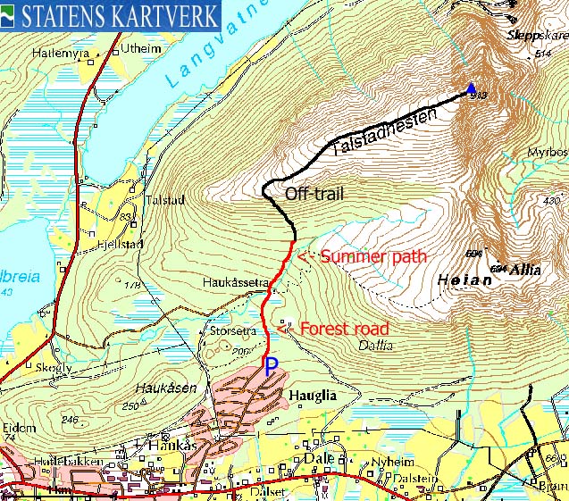
The most popular Talstadhesten routes begin at Haukåssetra, easily reached on forest roads. From Haukåssætra, a summer path runs steep up northbound to the lower section of the southwest ridge. Another route runs up to the Allia - Talstadhesten saddle, and then steep up to the summit. This web-page describes a winter ascent that runs close to the summer path.
Talstadhesten is well described in the book Turbok for Molde og Omegn (Olsen/Pedersen)


Talstadhesten (Norge 1:50,000: 913m, Økonomisk Kartverk: 912,65m, UTM 32 V 409141 6974193) has a primary factor of 805m, towards the higher parent Kvannfjellet (980m). The saddle is found by Fræneidet, along highway RV64. Ref. Økonomisk Kartverk (5m contours), the saddle is within the range 105-110m, interpolated to 108m.
Google's interactive map. You can zoom, pan and click on the markers.
Notes: Class ratings are in reference to YDS. Click here for more information.
The trails described below are not necessarily the *easiest* trails to this mountain.
|
Hauglia - Talstadhesten (winter)
|
|

Access
From the city of Molde, follow highway E39 eastbound (Kristiansund/Åndalsnes). Approx. 4Km from the E39/RV662 junction in Molde, turn left towards Eide. You can either follow the new tunnel (toll - NOK 15,- per Feb. 2007) through the mountain Tussen, or follow the old road around. After the tunnel, continue down to the sea, pass a distinct hill to your left (Skoften, 368m) and in the upcoming RV663/RV64 junction, turn left.
Drive 4,5Km to Elnesvågen and turn right towards Hauglia. Follow Hauglivegen 1,1Km upwards, turn left onto Øvre Kongsfaret road, drive 100m, and turn right onto Ridderbakken road. Proceed 300m to the trailhead
The route
Follow a forest road 700m northbound to Haukåssetra. Cross the river/creek on a bridge, and follow the "T" marked route northeast along the creek. At 280m elevation, the path turns northbound and heads more or less straight up the forest. On skis, gradually traverse forest slightly more to the northwest, before topping out on the ridge at approx. 530m.
Follow the ridge upwards. Pass two cairns before the terrain levels out for a short distance. Continue upwards to the summit. Note that the final yards to the summit are quite narrow compared to the rest of the ridge. But nothing to worry about, as long as you stay away from any cornices facing north.
Descend your ascent route, unless weather/conditions permit a (steep) descent to the Allia - Talstadhesten saddle, and a subsequent trip along the river/creek back to Haukåssetra. In good weather/snow conditions, the descent route is the prefered ski-route.
 westcoastpeaks.com
Other Møre & Romsdal mountains
Other Norwegian mountains
westcoastpeaks.com
Other Møre & Romsdal mountains
Other Norwegian mountains

