
A nice evening before this week-ends low pressure is setting in.


No Javascript:
Snowmelt still in progress. Soon, one can walk on grass again, all the way up. Strong wind at the top (21:20PM) made taking panoramas impossible. A nice walk, after a day with "countless" hailshowers.


No Javascript:
After a proper snowfall, came the rain. The driving conditions on the side roads were hopeless. I decided to take a trip to Høgkubben on Traktorveien. If any routes already had visitors this morning, this would have to be the one.
My dog Troll walked halfway up to the Oscarhytta cabin before he asked for a backpack ride. I chatted with another hiker for a good twenty minutes at Oscarhytta, before moving on. A woman then caught up with me. After a few sentences, I asked her if she was from Bindal (southern Helgeland), and she was. Pin-pointing her place of birth on first attempt is a good ice-breaker.
Above the Einarhytta cabin, the tracks ended. The snow was just hilariously deep. While I managed to follow the trail, the snow only reached my knees. Once I lost the trail, the snow went even higher. When we tried to make a short-cut up the mountain, I had snow up to my hips, and progress was very slow. I congratulated myself for leaving the gaiters back home. My fellow hiker took over the trail-breaking job, and we reached the top 14:30PM.
There was a strong gale at the top. Standing upright wasn't all that easy. To avoid not getting too cold, we turned around after a few minutes. Back at Oscarhytta, Troll could walk again, and took the lead all the way to Blindheim.


No Javascript:
Plan A on this Sunday was Snøhornet (1309m) in Ørsta. On skis. A friend (and his family) would look after Troll while I went out and had myself a proper mountain. On Saturday evening, a bad back put the plan at risk, but I sent him a SMS at midnight. The plan was a go. I slept bad through the night, waking up every other hour. My alarm clock was set to 06:30AM, but my friend sent me a SMS 06:00AM (!), suggesting that the visit should be postponed. Yes! At least one more hour in bed..
Plan B was a short ski-trip in the Tresfjorden area. Helsetnakken perhaps. I loaded all the gear into the car and headed out. My back was still aching, the wind was freezing cold, the ice on the road demanded full focus, and in Brusdalen it began to snow.
"Hell, no" and plan C was the final route to Høgkubben that I still hadn't done. I turned around halfway through Brusdalen and drove to Blindheim. The dog (Troll) and I left the trailhead 10:10AM, and as another dog had walked this path lately, my Troll was quite willing and able.
We had a nice stroll up the forest, eventually joining the path from Eikenos, that we hiked the night before (see trip report Jan 20 below). The path was well traveled by now, and Troll made it up to Høgkubben on his own. We reached the summit 11:20AM, and the place was just as cold as the night before. A vague plan involving crossing Blindheimsfjellet, got cancelled.
I could have descended the ridge route (Stien) back to Blindheim, but the dog's happiness is at its peak when he can backtrack his own steps. So I decided to descend our ascent route. Several other hikers were on their way up the mountain, and I had a pleasant chat with a few. We were back at the trailhead at noon. I had now walked all of the paths that I had planned to, ref. map in the last picture, and concluded that I knew a lot more about Uksenøya island than I did when I moved up here one year earlier.
Back home, it was time for a rest. Little did I know that I would wake up a bit later to an earthquake.


No Javascript:
There were still a couple of popular routes to Høgkubben that I didn't hike last year. The trail from Eikenos, being one of them. Even if I could have driven to the parking at 190m, I chose to park 100m lower, maximising the walk for the dog.
I headed out 18:05PM. The plan was that if there weren't any tracks on this trail, I would go to Lake Røssevolsvatnet instead. But there were a set of tracks up the forest, running all the way to Høgkubben. While Ålesund was windy and cold, I had shelter in the forest. It was a very nice evening.
The snow was too deep for Troll going uphill, but he would descend most of the route on his own. After having passed 4 cabins, we reached the top 18:55PM. It was pretty cold up there, and Troll was howling after a couple of minutes. Time to head back down. We took the same route back down, and were back at the car 19:40PM. Only a few hours left of my on-duty week, and I am no longer citybound for the next 3 weeks :)


No Javascript:
0 1 2 3 4 5 6 7 8 9 10 11 12 13

This Friday offered eveything from the brightest moments to snowfall, repeating itself to boredom. Come evening, I had lost the interest in the evening hike, but "strengthened" myself in the very last moment. And what a beautiful evening it turned out to be.
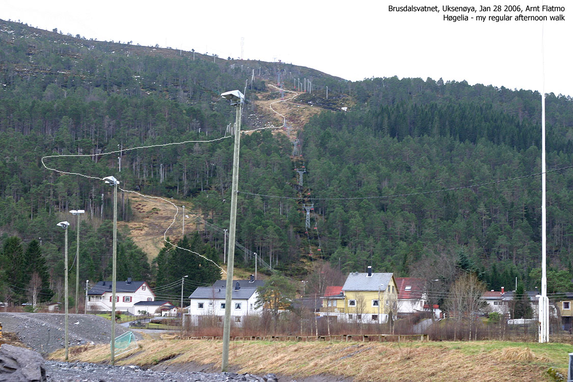
The lower section of the slalom hill would do harm on skis, but the upper part had potential. All that is needed is just some degrees below zero. In any case, I decided to walk. I carried my little friend up to the top of the slalom hill, which we arrived 20:40PM.
Troll, almost buried in snow, didn't want to hang around at the top, and complained loudly as I was taking pictures. Once I was done, he descended with great determination, rabbit style. I had problems keeping up. All in all, a fantastic evening. I'm glad I "kicked my butt" and got myself out the door.
Btw: the road between Hatlane and Moa was "all-time-high" icy. Only a touch on the steering wheel would make the car slide sideways, and only a brief touch on the brakes enabled the ABS system. The cars moving in and out of Moa looked like a funeral party. I've had my share of icy Norwegian roads, but I don't think I ever came across something like this before.
This route is described as route 4 on the Uksenøya main page


No Javascript:
The first hike on Blindheimsfjellet in '07. The plan was to go all the way to the high point (Høgkubben), but the snowdepth, the snowfall and the wind made me settle for the top of "Turheisa". On this hike, I got to test my new flashlight. A very powerful Pila GL3 that sat a new standard for lighting up a forest. This expensive (almost NOK 2000,-) torch is now a standard component of my emergency kit.
The peaceful hike was interrupted by a couple with two dogs, looking for the 3rd - a Pointer puppy. The puppy was well taken care of by some kids down by the parking, while the owners searched for him on the mountain. While I never will understand why people unleash dogs without the necessary control, I had to figure out what to do. Should I bring the puppy up the mountain? Should I wait? There were two routes down from the top, so I had to rely on that they had the wisdom enough to split up, and that one person would search from the trailhead and up.
To keep the puppy in place, I let him play around with my dachshund - Troll. The Pointer looked at Troll and figured - "hey, this bloke is smaller than me!. I can floor him!" And Troll exercised great patience and conscutive evasive maneuvers until one of the owners returned to the trailhead. THEN, we could go home.
This route is described as route 4 on the Uksenøya main page


No Javascript:
 westcoastpeaks.com
Other Møre & Romsdal mountains
Other Norwegian mountains
westcoastpeaks.com
Other Møre & Romsdal mountains
Other Norwegian mountains