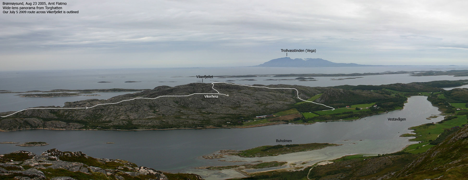
Norwegian Mountains, NordlandVikerfjellet, 145m
|
| Fylke/Kommune : | Nordland/Brønnøy |
| Maps : | 1725-I Brønnøysund (Statens Kartverk, Norge 1:50 000) |
| Primary factor : | 142m |
| Hiked : | July 2009 |
| See also : | Torghatten |
| See also : | Other Nordland mountains on westcoastpeaks.com |

Vikerfjellet is one of two tops on Torget island, just southwest of Brønnøysund. The other Torget top is Torghatten - known throughout Norway for its characteristic hole through the mountain, and consequently - the associated legend. Vikerfjellet is found on the west side of Torget island (Ytter-Torget) and Torghatten on the east side (Inner-Torget).
A part of the Vikerfjellet's south side is known as Vikerheia, and a well-marked path runs up here. Over the years, there have been various routes to Vikerfjellet. Some are closed now, but the 2009 route runs from Torgvikran. Ask around if this is where you would like to start from. This page will describe the normal route to Vikerheia, and then a rougher off-trail route to Vikerfjellet.
Vikerfjellet may look flat and easy when seen from a distance, but when you look closer, you will find deep clefts and the mountain suddenly becomes more "dramatic". Those who like to scramble, can enjoy a number of huge boulders - especially on Vikerheia.

Vikerfjellet (Norge 1:50,000: 145m, Økonomisk Kartverk: 144,60m, UTM 33 W 363670 7257760) has a primary factor of 142m towards the higher parent Torghatten (258m). The defining saddle (approx. UTM 33 W 364925 7258943) is found between Vestavågen and Skutstøa. Ref. Økonomisk Kartverk (5m contours), the saddle is within the range 1-5m, interpolated to 3m.
GPS measurement read 146m (on the cairn, ~1m high), averaged over a 5-minute period (error margin +/- 5m).
Google's interactive map. You can zoom, pan and click on the markers.
|
|
|
|
Route 1: Flymyrbakken - Vikerheia - Vikerfjellet (summer/autumn)
|
|
This route description is valid per July 2009
Access
(all distances are approx. distances)
The starting point is Brønnøysund. Follow signs towards Torget, and drive across the main bridge. Once on the Torget side, reset your odometer. Drive 9km, then make a right turn towards Ytre Torget (signposted). Drive 4,9km in the direction of Torgvikran (not signposted). The road turns into a gravel road after 2,8km. The Vikerheia trailhead (and parking) is now on your right-hand side.
The route

Follow the "T" path 1,1km up to the Vikerheia cairn. This is easy terrain. Scramble or climb the boulder, if you feel like it. You have Vikerfjellet in clear view from here.
You see a cleft between Vikerheia and Vikerfjellet. Continue (off-trail) 250m to the northeast before looking for a convenient place to get into this cleft. Getting up from it is also quite easy.
250m later, you arrive at another cleft. This one is trickier. Locate the highest point in the cleft, when you should be able to see a short and easy route into it. Diagonally ascend a grassy pitch, where you need to be careful on top. This is the exposed section.
Proceed north towards the summit. Yet another cleft appears, but this one is easily passed further to your right. Vikerfjellet summit is marked by a medium-sized cairn.
To make this a round trip, you have several options. You can follow the ridge towards Torgvikran, and then the road back to the Vikerheia trailhead. You can also head north towards Nordvika, but then you need another car there. A third option is to hike north/northeast 450-500m and descend to a forest road via the 80m contour. Einvolltinden is on the other side of this road. The forest road will take you down to the main road - 1,7km northeast of the Vikerheia trailhead.
No Javascript:
 westcoastpeaks.com
 Other Nordland mountains
 Other Norwegian mountains