|
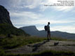
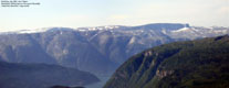
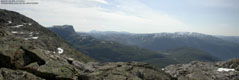
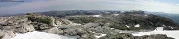
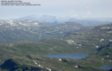
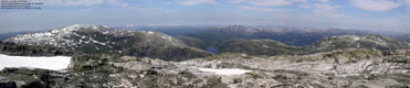
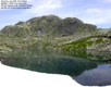
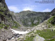
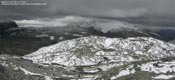
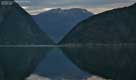
Skorafjell seen from Vatnasetenuten |
Skorafjellet is one of the many rounded peaks on the ridge running from Horndalsnuten (near Voss) to Vassfjøra (Ulvik). Horndalsnuten, Skipadalsnuten, Seldalsnuten, Olsskavlen and Nordbotnnuten are often referred to as "Raundalsegga", a ridge above the Raundalen valley. Skorafjellet and Vassfjøra is normally not considered a part of this ridge, but when looked from distance, there is no obvious change in the terrain.
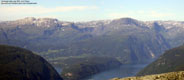
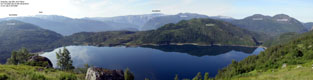
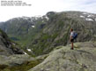
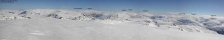
Skorafjellet is among the top 50 mountains in Hordaland, measured on primary factor. And the views won't let you down. You get a perfect view towards Hårteigen already at 1100m, and it only gets better the higher you go. The mountain itself has few characteristics, but compensates through the amazing views.
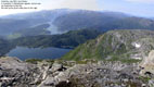
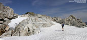
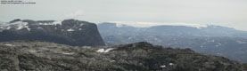
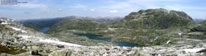
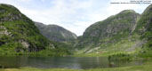
On the north side of the summit, you will find Såtaskavlen, which is a small glacier. Through slightly complex terrain, you will also find a high route towards Vassfjøra, the majesty among the Ulvik mountains. On the mountain's west side, you will find Tyssdalen valley with scenery you won't forget about in a long time. The steep "Fallet" (The fall) is the gateway to Tyssedalen from above, and a hike through this valley is an adventure by its own rights.
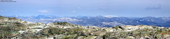
Due to the rounded form, Skorafjellet offers better views when Vassfjøra, although Vassfjøra is the undisputed king of the region. My co-hiker Torbjørn Frøystein stated that Vassfjøra expressed a great calm. When I view Vassfjøra from below, I agree to this fully. Nevertheless, the Skorafjellet traverse is a hike I will remember for a long time to come. What the mountain lacks in personality, it compensates through marvellous surroundings.
Primary Factor
Skorafjellet has a primary factor of 443m towards the higher Vassfjøra. The saddle is found between Skreppenuten and Reinskardnuten, and the 1140m 20m contours almost touch. As such, I have done no interpolation, and estimated the saddle height to be 1140m.
Note: Class ratings are in reference to YDS (Yosemite Decimal System).
Note: The trail described below is not necessarily the easiest trail to this mountain.
|
Solsævatnet - Skorafjellet - Fallet - Tyssedalen - Sotenos (summer/autumn)
|
|
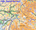
Access
From Bergen, two directions can be followed:
a) Follow E16 towards Oslo. Exit onto highway 7 at Trengereid, drive down to Samnangerfjorden, over Kvamskogen and down to Norheimsund. Follow highway 7 northbound all the way to Ulvik. From Ulvik follow the road to Espeland/Granvin for xxKm.
b) Follow E16 towards Oslo. From Voss, exit onto highway 13 towards Granvin. At lake Granvinsvatnet, exit left onto highway 572 (Espeland) and follow this road for xxKm.
You now have the exit to Solsævatnet on your left or right, depending on the way you drove. Drive on this gravel road until further driving is restricted by a gate (approx. 2Km) and park there. 1Km after you turned onto this road, you can see where the Tyssedalen trail joins the road. It is unmarked, but you should be able to see the trail.
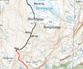
The route
To the summit
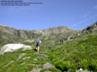
Pass the gate, and follow the road to lake Solsævatnet, where the road ends. The forest trail runs along the west shore of the lake, before gradually ascends towards Rubbelii. Do make sure you find the trail from the cabin. When you look towards the cabin, turn 2-3 o'clock, head towards the forest line and find the trail. The trail now very gently climbs towards the Skorelvi stream, where you have a magnificent view of the lake and the surrounding mountains. Hårteigen is easily seen as low as 1100m.
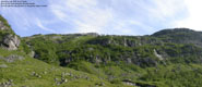
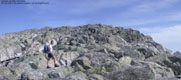
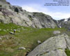
The trail now climbs steep but safe towards the north. You will see a large cliffband high above you. The trail will take you on the right hand side of this cliff, and into a small pass where a small shelter of stone has been put up. The trail ends here, and the route ahead runs north-east on, or near the Skorafjellet SW ridge. The terrain is sharp, rocky and cumbersome. By no means difficult, but you will be going from side to side, finding the best route.
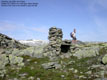
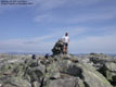
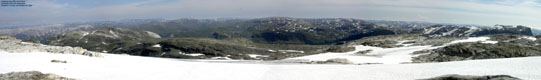
The summit is marked by a proper cairn and contains a summit register. The great north and north-east views are partly obscured by the summit plateau, so advance over the east side of the summit for the really good views.
Down via Fallet and Tyssedalen
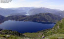
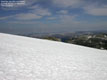
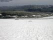
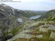
From the summit, you can maintain a fairly direct NW route down to the lakes in Tryglabotnen. You may want to walk on the outskirts of Såtaskavlen, which I'm not really sure is a glacier or permanent snow. The sooner to you start the descent to the SE end of the lake in Tryglabotnen, the better. You will then avoid some steeper terrain. Pass lake 1091 on the south side, find a good place to cross the drain, and then get on the high ridge on the other side of the drain. Follow this high ridge all the way to 1000m, where you turn left and heads towards Fallet and the "T" trail from Mjølfjell.
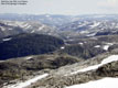
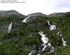
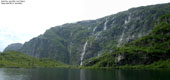
Fallet is a quick and safe way of getting down into Tyssedalen valley. Now you have quite a hike before you. Not only in terms of length, but also in terms of scenery. Tyssedalen is enclosed by high, vertical mountain sides with spectacular waterfalls. You eventually join the gravel road by Sotenos. Then turn left and hike back to the gate where you parked.
|
After a less inspirational night in a hotel in Ulvik, but with nice hikes to Austdølnuten and Kyrelvfjellet the day before. I was rather tired after 1,5 hours of sleep when Torbjørn Frøystein picked me up outside the hotel at 07:20AM. We then parked one car at the Vassfjøra trailhead in case this would be our return route, and drove the other to the parking before lake Solsævatnet. Even if Vassfjøra was the majesty of Ulvik, I still wanted to do Skorafjell first. And as Torbjørn had never been to Skorafjellet, that decision was easy. We were on our way 07:45AM, and I was carrying Troll. The trail up the forest was a little too complex for the little one. Near Rubbelii, we spent a good 20 minutes locating the trail on the other side of the meadow. As we approached Skorelvi, we had the first photo break as the scenery was just awesome. The road ahead was quite clear. Steep and long. We could follow the trail all the way to 1160m, but from then on, the route was over rough and sharp rock. Even if I had carried Troll most of the way, I really enjoyed this hike. The scenery was brilliant, and so was the weather. And it was nice having good company in Torbjørn. Being from the district, he knew most of the nearby places that we could see from our position. We reached the summit 11:15PM, which meant it had taken us 3,5 hours to get there. Not too bad, we reckoned, even if we could cut this time significantly under different circumstances. After all, this was no race. Just a nice stroll up the mountain. We agreed on that Skorafjellet offered better views than Vassfjøra, even if Vassfjøra was a higher mountain. The Skorafjellet summit plateau is rather small, while Vassfjøra has a long northern ridge, blocking the below views. I also took Skorafjellet's primary factor into consideration, which was almost 100m more than Vassfjøra's. Higher factor normally gives better views. We decided to abandon Vassfjøra and return via Fallet and Tyssedalen instead. The hike would be long as it was, and the distance over to Vassfjøra was longer than I had anticipated it to be. Besides, we both would like to return to Bergen in civilized time. At 11:45PM, we left the summit and hiked across parts of Såtaskavlen. Ice was visible just below us, and we decided to stay west of the snow. We then kept a steady route down to Tryglabotnet, avoiding the steepest parts above the lakes. We had to do cross a drain down by the lakes, which was far easier for Torbjørn (long legs) than for me (shorter legs, dog on the back). But soon, we reached Fallet. I had expected this to be a steep and perhaps exposed section, but it was a trivial hike down to the valley. On the way down, we had to cross the river, and once again Torbjørn had the advantages. The hike down Tyssedalen was quite long. I spent the time admiring the steep mountain walls on each side of the valley, and some amazing waterfalls. Troll was now walking, which was good, as I had grown a bit tired from the extra weight. I'm really not a valley kind of guy, but this valley was a wonderful place. I didn't really mind the length of it (7Km +). At last, we reached the road and hiked back the remaining kilometer to the car. At 16:00, the journey and a 7h:45m hike was over. I hope for a quick return to the area, as Vassfjøra is really high on the to-do list. Hopefully, Torbjørn can come along for the hike. He's been there three times already, but the plan is to explore a new route (new to him), which may offer some exposed sections.
|
Move cursor to read notes, and click on the images to see full version.
Some of the thumbnails may have been cropped to fit the format.
Pictures are presented in the order they were taken.


 Other hordaland mountains
Other Ulvik K. mountains
westcoastpeaks.com
Other hordaland mountains
Other Ulvik K. mountains
westcoastpeaks.com